Tanager-1 A New Era in Monitoring Climate Change

The non-profit organization Carbon Mapper is stepping up the fight against climate change. They are using advanced satellite technology to monitor greenhouse gas emissions closely. This innovative approach demonstrates how high-tech environmental monitoring can inspire real action and foster creative solutions.
Tanager-1 Satellite Launch
The recent launch of the Tanager-1 satellite marks a significant achievement for Carbon Mapper. This initiative enhances our ability to combat climate change through technology. Tanager-1, developed in partnership with NASA’s Jet Propulsion Laboratory (JPL) and Planet Labs PBC, features an advanced imaging spectrometer. It can detect methane and carbon dioxide emissions precisely, even from remote areas.
Tanager-1 has a global reach. It doesn’t just monitor emissions in the United States. It also tracks emissions in international hotspots, contributing to global climate change efforts. This launch showcases Carbon Mapper’s commitment to tackling climate challenges worldwide.
Visualizing Greenhouse Gases
Tanager-1 took flight on August 16 from Vandenberg Space Force Base. It represents a collaboration of diverse minds with a shared vision. Thanks to its sophisticated imaging, Tanager-1 can monitor greenhouse gases that were difficult to track before.
James Graf, director for Earth Science and Technology at NASA’s JPL, said, “The first greenhouse gas images from Tanager-1 are exciting and a compelling sign of things to come.”
Tracking Global Emissions
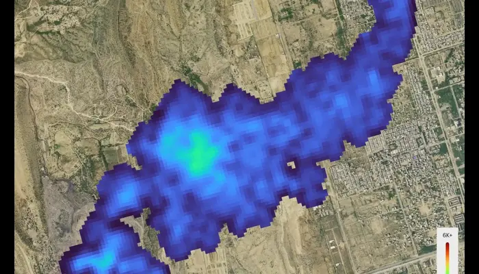
Already, Tanager-1 has captured images of methane and carbon dioxide over areas like Pakistan, South Africa, and Texas. These images highlight the impact of human actions on the planet. By collecting detailed data, Carbon Mapper can estimate emission rates, enhancing our understanding of climate change.
Tanager-1’s advanced imaging spectrometer detects specific chemical compounds beyond the visible spectrum. It identifies a unique “spectral fingerprint” for different substances, allowing accurate emissions monitoring at the facility level.
Sharing Data for Change
The Carbon Mapper team aims to make this crucial information accessible. Tanager-1 scans large areas of Earth daily, with data available through the Carbon Mapper data portal. This resource is invaluable for researchers and policymakers, empowering them to make informed decisions to combat greenhouse gas emissions.
The Origin of Carbon Mapper
Carbon Mapper arose from the urgent need to address climate change effectively. Its main goal is to enhance monitoring of methane and carbon dioxide emissions worldwide. The organization focuses on providing transparent, accessible data to drive global climate solutions.
With the support of visionary philanthropists and strong public-private partnerships, Carbon Mapper is revolutionizing satellite monitoring. This fleet of satellites delivers real-time, precise insights into greenhouse gas emissions, transforming our understanding of their impact.
Carbon Mapper aims to create a real-world impact on climate policy and action. With Tanager-1 leading the way, it envisions a future where emissions data is accessible to everyone, not just scientists and policymakers. This openness encourages everyone to feel a sense of responsibility and urgency, inspiring action to reduce carbon footprints.
Expanding the Carbon Mapper Network
Looking ahead, Carbon Mapper plans to launch more satellites, creating a more detailed map of global greenhouse gas emissions. This expanded network will allow for continuous monitoring and rapid response to emission spikes. By raising the standards in environmental monitoring, Carbon Mapper is paving the way for a cleaner, more sustainable future.
Follow us on Google News, Instagram, YouTube, Facebook,Whats App, and TikTok for latest updates


