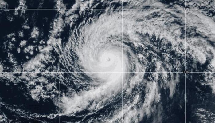
Hurricane Kiko, once a powerful Category 4 storm, is now weakening and shifting northward, reducing the threat of destructive winds and heavy rainfall for Hawaii. Meteorologists say the storm will continue to lose intensity as it approaches cooler waters and encounters strong wind shear.
From Category 4 to Category 3
Earlier this week, Hurricane Kiko rapidly intensified, moving from a tropical storm on Monday to a Category 4 hurricane by Wednesday. At its peak, the storm packed winds of up to 145 mph while tracking about 1,300 miles southeast of Hawaii. However, by Saturday afternoon, the storm weakened to a Category 3, with sustained winds around 120 mph.
Forecasters expect Kiko to lose more strength in the coming days, potentially downgrading to a tropical storm before it nears Hawaii early next week.
Emergency Preparations in Hawaii
Despite the diminishing threat, Hawaii officials prepared for possible impacts. Acting Governor Sylvia Luke declared a state of emergency on Friday, ensuring resources were available if the storm shifted unexpectedly. The proclamation allowed for quick mobilization of emergency services and supplies.
“The threat for any wind is diminishing,” said Joseph Clark, a meteorologist with the National Weather Service in Honolulu. “With the storm going north, it tends to actually make the winds lighter than normal over the islands. So if the current track holds up, the winds will be pretty light, and it might end up being hot and muggy without much wind.”
Tonight’s Lunar Eclipse Promises a Stunning Blood Moon
The night sky will put on a spectacular show as a total lunar eclipse rises on the evening of 7–8 September. Often called a “blood Moon,” the rare celestial event will be visible across the…
Limited Rain and Localized Effects
While Kiko is not expected to bring widespread downpours, isolated rain showers could still affect parts of the Big Island and Maui. Meteorologists believe the bulk of the heavy rain and damaging winds will remain north of Hawaii, sparing residents from severe flooding or storm surge.
Still, forecasters caution that any southward shift could bring stronger rain bands across the islands. The situation continues to be monitored closely.
Dangerous Surf and Rip Currents
Even as winds weaken, Hurricane Kiko is producing large ocean swells. The National Weather Service warned that waves of 10 to 15 feet are likely along east-facing shores of the Big Island and Maui beginning Sunday. These swells could cause beach erosion and create life-threatening rip currents.
Residents and visitors are advised to avoid swimming in affected areas and to follow safety guidelines issued by local authorities.
Powerball Jackpot Climbs to $1.8 Billion, Second-Largest in History
The winning numbers for Saturday’s Powerball jackpot, estimated at a record-breaking $1.8 billion—were drawn as 11, 23, 44, 61, 62, with a Powerball of 17. The grand prize, carrying a staggering cash value of $826.4…
Uncertainty Remains
Meteorologists remain confident that Hurricane Kiko will continue tracking north, away from Hawaii. If this trajectory holds, the islands will be spared the brunt of the storm. However, forecasters stress that hurricanes can shift quickly, and any movement back to the south could increase the risk of heavy rain and strong winds.
For now, Hawaii faces hot, humid conditions with minimal wind, while the ocean carries the storm’s most dangerous effects. Authorities urge residents to remain cautious and updated as the storm system evolves.
Follow us on Instagram, YouTube, Facebook,, X and TikTok for latest updates


